Severe thunderstorm warnings, tornado watches in Saskatchewan
-
Share on Facebook
-
Share on Twitter
- Copy Link
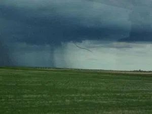
Much of southern Saskatchewan will be hit with more rain Tuesday afternoon, but there is the potential for much more with tornado watches and severe thunderstorm warnings and watches in place.
As the alerts change very quickly, you can view a map with the latest warnings and watches here.
Dan Kulak with Environment Canada warned that a system moving through the far south-east corner of Saskatchewan was carrying a lot of rain, as well as having the potential for hail. With any severe thunderstorm, there's always the possibility of tornadoes.
“The system of the storms right now are actually very slow moving, it's an unstable air mass. We're probably going to be looking at storms through the latter part of the afternoon, perhaps even into the evening hours.”