Click here to sign up for our free daily newsletter.
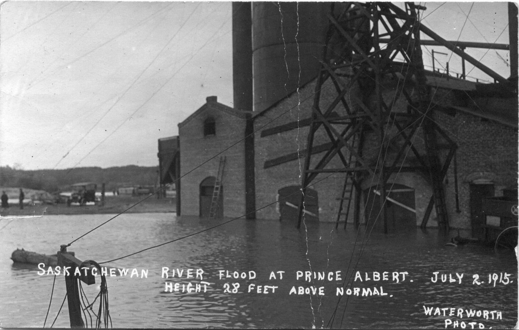
A fully loaded train helps weigh down the Prince Albert train bridge to prevent it from being washed away during the flood of 1915. (Image Credit: Prince Albert Historical Society/Facebook)
Local history

Reliving the tales from some of Prince Albert’s worst floods on record

May 1, 2026 | 6:00 AM

Spring has officially sprung in Prince Albert after the ice on the North Saskatchewan River broke up on Wednesday

While the event is normally celebrated, there have been instances in history where the ice breaking up on the river has caused some of the worst flooding in the city’s history. 

Read below about some of the stories and details from those tense times: 

The Great Flood of 1875 

On Jan. 1, 1890, the Prince Albert Historical Society lost everything to a fire when the Nisbet Academy burned down.  

A few decades later, in 1923, a few businessmen attempted to revive the society, asking older residents to write about their memories from years prior. Two people contributed stories about the Great Flood of 1875, one of whom was a woman named Margaret MacKenzie. 

MacKenzie was the second oldest child of five siblings to William Miller and Jessie Hume, who had moved the family to the Prince Albert area sometime in 1873 from Winnipeg. When they arrived, the family settled on a river flat near the North Saskatchewan River and built a homestead. 

Two years later, in 1875, the river began to overflow its banks due to an ice jam where the North and South Saskatchewan Rivers meet just east of the city. 

According to MacKenzie, the family was up at around 6 a.m. that morning and packed what they could into their wagon to head for higher ground. MacKenzie had a favourite calf she did not want to leave behind, but she had to abandon her pet as the water quickly rose above her waist. Her home was submerged in three-foot deep flood waters, and some hens that the family had brought from Fort Garry, now Winnipeg, drowned in the flood. 

The family managed to climb the hill where they were forced to camp for three days. Despite the chaos and devastation, a visitor came by to check on the family. His name was Rev. Hugh McKellar, a Presbyterian minister who had trekked through deep snow and slush to reach the family’s camp. MacKenzie’s father, William, was impressed by the Reverend’s efforts and was quoted saying, “From now on, I am your friend. Any man who (would) do as you have done is a true friend.” 

Following the flood, the family built a permanent settlement on the hill and became very involved with the community. William was the head of several committees and organizations at the time, and was one of four men who helped build the city’s first school. Their efforts were later recognized by the City when it dedicated a park to the family in the Riverview neighbourhood called Miller Hill Park. Today, residents would know the area where they settled as Miller’s Hill.

MacKenzie later wrote a book about the effects and tragic results of the flood, titled The Voice of the People. 

The second person who told a tale from the 1875 flood was an Indigenous man named James Grain. He spoke of Aboriginal people who lived in the area and how they used to harvest syrup and sugar from maple trees on some islands in the river. 

On the day of the flood, a group of 10 to 12 people were working on one of the islands, near where the Saskatchewan Penitentiary is today. A sudden thaw saw the ice break up and jam, and by sunrise, the workers were trapped on the island. With the water rapidly rising, workers were forced to climb the tallest spruce trees while leaving the majority of their stuff behind.  

After two days of surviving in the trees, some of the children and older workers became worn out, and one by one, fell into the rushing river waters below until there were just two left – a young man and a young woman. Knowing they would be next, the man used a French woven belt, wrapped it around himself and the girl, and tied it to the tree so they wouldn’t fall into the water if they fell asleep.  

His efforts paid off as the belt held strong and helped the two survive. They were eventually rescued from the island. The man, who was James’ uncle Henry Grain, later married the girl in Prince Albert. 

James Grain told two more stories from that day, including one about a family narrowly escaping from their home and another about a group of workers who were trapped on an island on the South Saskatchewan River. They needed to build a raft to survive. Those stories can be found here

The Flood of 1915 

The flood in the summer of 1915 was the worst, on record, that the city has ever experienced. 

Brought on by heavy rainfall, rapid mountain snowmelt and ice jams, water levels rose 28 feet (8.5 metres) above normal and was considered a 1-in-200-year event.  

The river was flowing at an insanely fast rate of nearly 5,660m3/s, which is fast enough to fill two Olympic sized swimming pools simultaneously every single second. The water was flowing so rapidly that residents in Prince Albert needed to park a loaded train on the train bridge to weigh it down to prevent it from being swept away. 

Water covered what is now developed neighbourhoods in P.A.’s West and East Flat, along with a portion of modern day Hazeldell, destroying many homes and businesses in the area including the Prince Albert Lumber Mill.

The Prince Albert Lumber Mill was one of the many businesses affected by flooding in July 1915.
The Prince Albert Lumber Mill was one of the many businesses affected by flooding in July 1915. (Image Credit: Prince Albert Historical Society/Facebook)

More recently 

The city has experienced more than its fair share of other serious floods and high-water events during its existence, with the most notable coming in 1974 and 1980. 

The flood of 1974 was the second-worst flood on record and was considered a 1-in-100-year event. It was documented that the river was flowing near the same rate as the flood in 1915. A large area of the West and East Flat neighbourhoods were affected with many homes and businesses being flooded or submerged.  

The 1974 flood changed the way the city manages the river and, today, is still one of the key events engineers and planners refer to when assessing flood risk. 

Two pictures show the water levels of the North Saskatchewan River during the 1974 flood in Prince Albert.
Two pictures show the water levels of the North Saskatchewan River during the 1974 flood in Prince Albert. (Image Credit: Prince Albert Historical Society/Facebook)

Unlike the other floods where ice jams played somewhat of a factor, the flood of 1980 was primarily caused by sustained high flow volume.  

While it didn’t cause as much damage compared to the other floods, the water still managed to spread into low-lying residential and industrial zones in the West Flat and caused some localized flooding in the East Flat. The response to the flood was also better than before, as the city had learned from what happened in 1974. River monitoring and flood warnings were more effective, sandbags were used as temporary flood protection measures, and emergency response was better organized.  

The 1980 flood was classified as a moderate-to-major flood and was deemed a reinforcing event, showing that even smaller floods could still cause damage. 

Less destructive, high-water events in 1986, 2011, 2013 and 2020 are still noteworthy in their own regard. All four events were triggered by heavy precipitation and spring runoff, while 2013 was also contributed to record water being released from the Gardiner Dam. 

Little Red River Park was forced to close in 2013 when Anglin Lake overflowed and caused extensive flooding; barriers were needed to protect Cosmo Lodge. The flooding was also due to the Gardiner Dam releasing record levels of water, which played a bigger role in what happened downstream.  

The majority of Little Red River Park was underwater in 2013.
The majority of Little Red River Park was underwater in 2013. (Image Credit: File photo/paNOW Staff)

Around 2,000 residents in Cumberland House and Cumberland House Cree Nation were forced to evacuate because of the flooding risk, and they were sent to Prince Albert, Nipawin, Melfort and Saskatoon. 

The community did eventually flood and its main road was washed out as water flowed past. Fortunately, no homes or other infrastructure in the community were damaged when the water hit its peak.

Crews race to erect barriers around buildings in Cumberland House in anticipation of a flood back in 2013.
Crews race to erect barriers around buildings in Cumberland House in anticipation of a flood back in 2013. (Image Credit: THE CANADIAN PRESS)

2011 was the largest of the four events and was the closest thing to an actual flood. River levels were the highest and longest lasting, with flows reaching near major-flood thresholds similar to that of what was seen in 1974. It was also the most damaging, causing yard flooding, basement seepage, and extensive flooding to parks and trails. 

1986 and 2020 are comparable in terms of size and are deemed moderate-to-high events. The 1986 event was significant for its time and did cause some localized flooding in the East and West Flat neighbourhoods. Meanwhile, 2020 saw minimal flooding within city limits but it heavily affected areas north of P.A., where the city was forced to close Little Red River Park for the second time in less than 10 years, as well as the boat launch. 

Today, flooding has started to stabilize in several Saskatchewan communities, but provincial officials warn the risk is not over as warmer weather moves in. The Saskatchewan Public Safety Agency, municipalities and other officials will be keeping a close eye on rising waters, with the hopes of avoiding another flooding event for the history books.

-with files from the Prince Albert Historical Society and the City of Prince Albert 

— 

loganc.lehmann@pattisonmedia.com