Click here to sign up for our daily newsletter
Runoff outlook

Spring runoff outlook varies across Sask.

Feb 7, 2019 | 5:00 PM

It sounds strange to speak about spring when it’s -50 C with the wind, but the Water Security Agency has released their first spring runoff outlook for 2019.

Much of the southern portion of the province is expecting below normal runoff.

“What we’re seeing is with the dry conditions in the summer and the fall of 2018, combined with our winter precipitation right now which has been below normal so far, I think we’re going to be looking at a below normal spring runoff in those areas,” said Patrick Boyle with the Water Security Agency

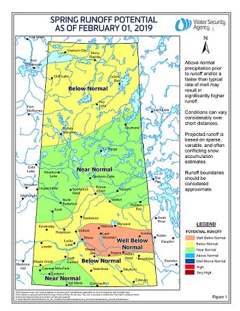
Areas including Melfort, Tisdale, Nipawin, North Battleford, Meadow Lake, and La Ronge are located in a region in central and northern Saskatchewan forecast to see near normal runoff.

Boyle said those near normal regions have generally had more precipitation this winter.

Prince Albert is just outside of that area, and is listed in the below normal runoff category.

(submitted photo/Water Security Agency)

The runoff outlook could still change significantly, as it will be a while before the snow melt.

Boyle said several factors would change the runoff outlook.

“The amount of snowfall we get right now will determine exactly how the spring runoff looks. Also, when the melt starts, and the rainfall we get on top of that and how much and where, can also change the picture,” said Boyle. “Whenever you have things melting and rivers starting to flow, and you add heavy amounts of precipitation on top of it, that can really start to move the needle when it comes to water flow and things happening.”

Major spring storms and drastic temperature increases during the melt could also lead to higher runoff.

The agency said in its forecast that it would take well above average precipitation over the next three months to produce an above average spring runoff in the drier areas of the province.

View Comments